Discover a comprehensive overview of Florida's vital salt marsh ecosystems with detailed maps designed for U.S. explorers and conservationists. This guide provides key information on where to find these crucial coastal habitats, what unique wildlife they support, and how to responsibly access them. Learn about the diverse benefits salt marshes offer, from protecting coastlines to serving as nurseries for marine life. We cover popular viewing spots, public access points, and options for guided tours or kayak rentals. Whether you are planning a visit, conducting research, or simply curious about these natural wonders, this resource helps you navigate the rich biodiversity and geographic spread of Florida's salt marshes. Find out why these areas are essential for the state's environmental health and what steps you can take to experience their beauty firsthand. Use this information to confidently decide where to go, what to look for, and how to engage with these irreplaceable landscapes.
- What kind of plants grow in Florida salt marshes? - Florida salt marshes are dominated by hardy, salt-tolerant plants. The main species include smooth cordgrass (Spartina alterniflora) in lower, frequently flooded areas and black needle rush (Juncus roemerianus) in higher marsh zones. These plants are crucial for stabilizing the soil and forming the base of the marsh ecosystem, adapting to the unique brackish water conditions.
- How do salt marshes help clean water? - Salt marshes act as natural water filters. Their dense vegetation and underlying sediments trap pollutants, excess nutrients, and sediments from runoff before they reach larger bodies of water. This filtration process significantly improves water quality, benefiting adjacent estuaries and coastal marine environments by removing harmful substances and preventing eutrophication.
- Are all salt marshes in Florida open to the public? - Not all salt marsh areas in Florida are universally open to public access. While many significant marshlands are preserved within state parks, national wildlife refuges, and other public lands with designated access points, some areas might be privately owned or have restricted access for conservation purposes. Always check local regulations and maps for specific entry information.
- What is the best way to see wildlife in a Florida salt marsh? - To best observe wildlife in a Florida salt marsh, consider visiting during cooler parts of the day, like early morning or late afternoon, and during low tide when more mudflats are exposed for foraging. Using binoculars is highly recommended. Kayaking or paddleboarding in designated channels, or walking boardwalks at state parks, provides excellent, respectful viewing opportunities without disturbance.
- Do Florida salt marshes change with the seasons? - Yes, Florida salt marshes do experience seasonal changes, although less dramatically than temperate marshes further north. Plant growth might be more vigorous in warmer months. Migratory bird populations fluctuate, with many species arriving in the fall and winter. Water levels also vary with rainfall and tidal cycles, influencing accessibility and the distribution of marine life within the marsh environment.
- Are salt marshes safe to visit alone? - While generally safe, visiting salt marshes alone carries some risks. Tides can change rapidly, potentially leaving kayakers stranded. Wildlife, though typically shy, should be respected from a distance. It's always advisable to visit with a companion, inform someone of your plans, carry a fully charged phone, and be prepared for sun and insects. Staying on marked paths enhances safety.
- How can I help protect Florida's salt marshes? - You can help protect Florida's salt marshes by practicing responsible recreation, such as staying on marked trails and disposing of trash properly. Support local conservation efforts through volunteering or donations. Educate others about their importance and advocate for policies that safeguard coastal wetlands. Avoid disturbing wildlife and never remove plants or animals from these delicate ecosystems.
What is the best time to visit Florida salt marshes?
The best time to visit Florida salt marshes is typically during the cooler, drier months from late fall through early spring (November to April). During this period, temperatures are more comfortable, and insect activity, particularly mosquitoes, is significantly reduced. Wildlife viewing opportunities, especially for migratory birds, are often enhanced, making for a more enjoyable and productive visit to these coastal habitats.
Are there any guided tours specifically for Florida salt marsh exploration?
Yes, many areas across Florida offer guided tours specifically designed for exploring salt marshes. These often include kayak, canoe, or small boat tours led by experienced naturalists. Operators in locations like St. Augustine, Cedar Key, and near the Canaveral National Seashore provide educational insights into marsh ecology, wildlife spotting, and safe navigation. Searching online for 'Florida salt marsh tours' will reveal local options and booking details.
How do Florida salt marshes protect the coastline?
Florida's salt marshes play a critical role in coastal protection by acting as natural buffers against erosion and storm surge. Their dense root systems stabilize shorelines, preventing soil loss. The extensive vegetation also helps to slow down and absorb the energy of incoming waves and stormwaters, significantly reducing the impact of hurricanes and tropical storms on coastal communities. This makes them indispensable natural infrastructure.
What is the difference between a salt marsh and a mangrove forest in Florida?
While both are coastal wetlands, salt marshes and mangrove forests differ primarily in their dominant vegetation and geographic distribution. Salt marshes are characterized by salt-tolerant grasses (like Spartina) and thrive in temperate to subtropical zones, typically in North and Central Florida. Mangrove forests, dominated by mangrove trees, are found in more tropical, frost-free regions of Central and South Florida. They often transition into one another.
Can I fish in Florida's salt marshes?
Yes, fishing is a popular activity in many of Florida's salt marshes, as they serve as vital nursery grounds for numerous popular sport fish. Species like redfish, spotted seatrout, snook, and flounder are frequently targeted by anglers. However, it is essential to check local fishing regulations, including licensing requirements, size limits, and seasonal restrictions, which vary by location. Always practice responsible catch-and-release where appropriate.
Map of Salt Marshes in FloridaFlorida, a state known for its extensive coastline, holds vast and incredibly important salt marsh ecosystems. These unique wetland areas play a crucial role in the state's environmental health and support a diverse array of plant and animal life. For anyone looking to understand, explore, or simply locate these natural wonders, a detailed map of salt marshes in Florida serves as an indispensable tool. This guide will help you navigate the landscape, identify key locations, and learn how to responsibly experience these valuable habitats.
Understanding where these marshes are situated allows both residents and visitors to appreciate their ecological significance. They are not just muddy areas; they are vibrant, living filters that protect our shores and sustain countless species. Preparing with the right information, including maps and access details, ensures a more rewarding and informed visit to these vital coastal regions.
From the panhandle to the central coast, Florida's salt marshes are integral to its natural heritage. These maps provide the framework for discovering everything from prime bird-watching spots to ideal kayaking routes, all while highlighting the areas most critical for preservation and study. Get ready to uncover the beauty and importance of Florida's coastal wetlands.
What are Florida's Salt Marshes?
Florida's salt marshes are intertidal habitats found along low-energy coastlines, estuaries, and bays. They are dominated by salt-tolerant grasses, particularly smooth cordgrass (Spartina alterniflora) in the lower marsh and black needle rush (Juncus roemerianus) in the higher marsh. These wetlands are regularly flooded by tides, creating a challenging environment that only specialized plants and animals can endure.
These dynamic ecosystems act as crucial buffers between land and sea, mitigating storm surge and preventing coastal erosion. They filter pollutants from runoff, improving water quality for adjacent marine environments. Many species of fish, crustaceans, and birds rely on salt marshes for food, shelter, and breeding grounds, making them biodiversity hotspots.
The unique blend of fresh and saltwater, combined with tidal influence, creates distinct zones within a salt marsh. Each zone supports different plant communities and, in turn, different animal species. Understanding these characteristics helps in interpreting a map of salt marshes in Florida and appreciating the specific ecological niches present.
Key Characteristics of Florida Salt Marshes
Florida's salt marshes exhibit several defining characteristics that make them unique coastal ecosystems. They thrive in brackish waters, a mix of fresh and saltwater, which dictates the types of plant life that can survive. The regular ebb and flow of tides is another critical factor, influencing nutrient distribution and the movement of species within the marsh.
The dominant vegetation, such as Spartina and Juncus, forms dense, expansive meadows that stabilize the soil and create microhabitats. These plant communities are incredibly productive, forming the base of a complex food web. The detritus from decaying marsh plants provides essential nutrients for countless organisms, from microscopic bacteria to large fish.
Furthermore, these marshes are typically flat and extensive, often stretching for miles along the coastline. This topography allows for broad tidal flooding and creates a wide intertidal zone. When viewing a map of salt marshes in Florida, you will notice these areas often appear as broad, greenish-brown swathes hugging the mainland or surrounding barrier islands.
Ecological Importance and Biodiversity
The ecological importance of Florida's salt marshes cannot be overstated. They serve as critical nursery grounds for a vast array of marine species, including shrimp, crabs, and juvenile fish like red drum and spotted seatrout, which are vital to commercial and recreational fishing industries. Without these protected areas, many species would struggle to reproduce and grow.
Beyond marine life, salt marshes are havens for numerous bird species, both resident and migratory. Wading birds like herons and egrets forage for food, while various raptors hunt over the open marsh. They also provide essential habitat for terrestrial animals, including raccoons, otters, and various reptiles, all adapted to this unique coastal environment.
Moreover, salt marshes play a significant role in carbon sequestration, capturing and storing carbon dioxide from the atmosphere. Their dense vegetation and waterlogged soils create anaerobic conditions that slow decomposition, locking carbon away. This natural process helps in mitigating climate change impacts, highlighting another reason why mapping and protecting these areas is crucial.
Where Can You Find Salt Marshes on a Florida Map?
Florida's extensive coastline means salt marshes are found in many regions, primarily along the Big Bend and northeast coasts. These areas, characterized by their shallow, gently sloping shores and numerous estuaries, provide the ideal conditions for marsh development. Knowing these general locations helps pinpoint specific areas on a map for exploration.
When consulting a map of salt marshes in Florida, look for large estuarine systems and bays, particularly where rivers meet the sea. The transition zone between freshwater and saltwater is often where these productive ecosystems flourish. Public lands, state parks, and wildlife refuges frequently encompass significant marsh areas, offering protected access.
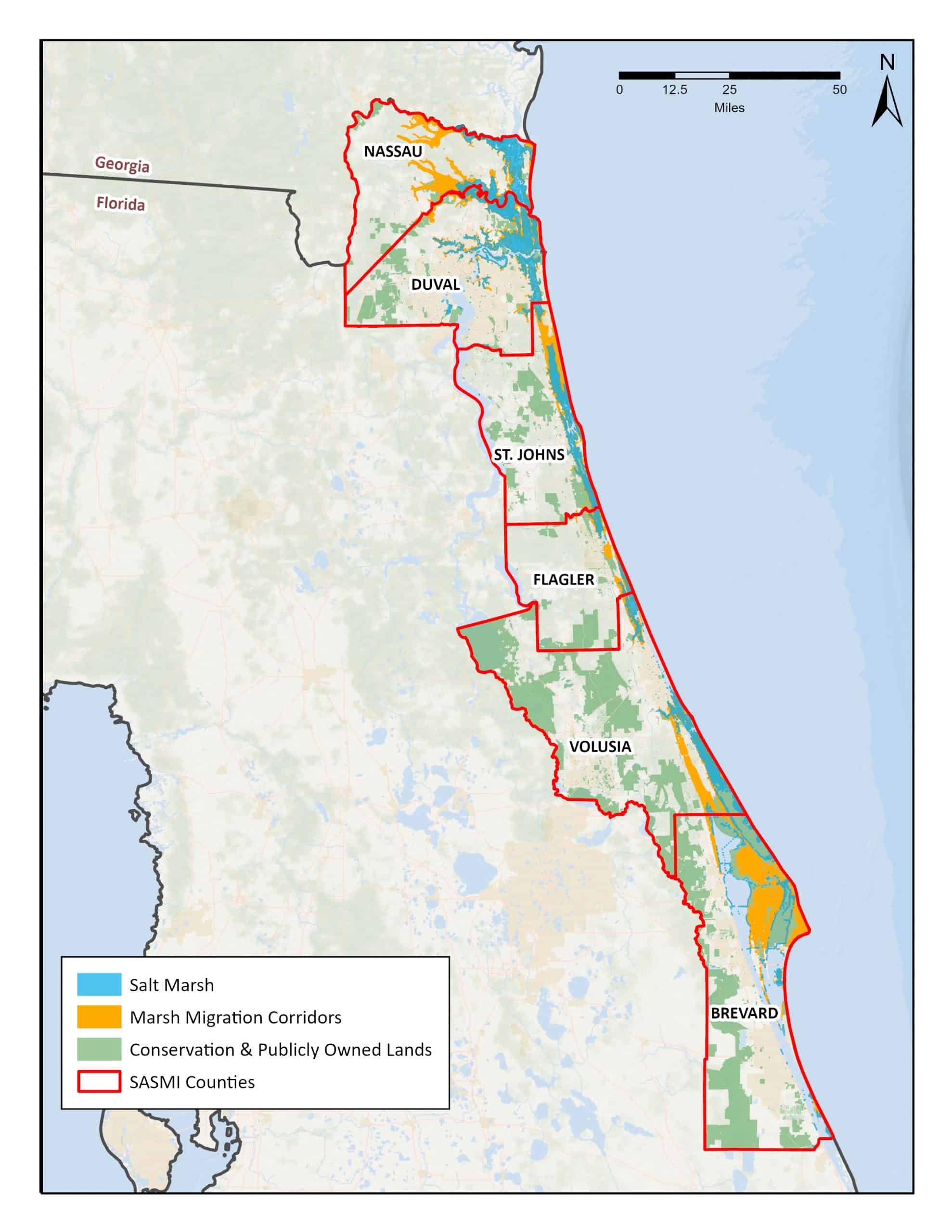
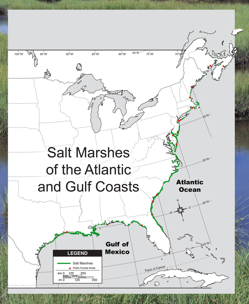
Key regions to focus on include the Gulf Coast, especially from Pasco County north to the Panhandle, and the Atlantic Coast from St. Johns County northward. These expansive areas provide the most extensive and accessible salt marsh habitats for nature enthusiasts and researchers alike. Detailed maps will highlight specific entry points and trail systems within these broader zones.
North Florida Coastal Salt Marshes
North Florida boasts some of the most pristine and extensive salt marsh systems in the state. The Big Bend region, stretching from Wakulla County to Pasco County, is a prime example, often referred to as Florida's 'Nature Coast'. This area features a remarkably undeveloped coastline, allowing for vast, uninterrupted marshlands to thrive.
On the Atlantic side, regions around Jacksonville, St. Augustine, and further north towards Amelia Island contain significant salt marsh acreage. These areas are characterized by robust tidal rivers and estuaries that feed into the Atlantic Ocean. Maps for these northern coastal areas often show an intricate network of waterways weaving through dense marsh vegetation.
Popular spots in North Florida include the St. Marks National Wildlife Refuge, Cedar Key, and the Guana Tolomato Matanzas National Estuarine Research Reserve (GTM NERR). These locations are well-documented on various maps, often with trails, boardwalks, and designated kayak launches, making them excellent places to visit and observe the marsh environment.
Central and South Florida Salt Marsh Areas
While North Florida has the largest continuous stretches, Central and South Florida also host important, though often more fragmented, salt marsh habitats. Along the central Atlantic coast, areas like Mosquito Lagoon within the Canaveral National Seashore and parts of the Indian River Lagoon system still contain vital marshlands. These typically occur in sheltered areas behind barrier islands.
On the Gulf Coast in Central Florida, the northern parts of Tampa Bay and the various estuaries feeding into it maintain smaller, yet ecologically significant, salt marsh patches. These areas often coexist with mangrove forests, forming a complex and highly productive ecotone. Maps here will show a blend of marsh and mangrove habitats.
Further south, true salt marshes become less common, giving way to extensive mangrove ecosystems that are more adapted to tropical climates. However, remnants or smaller, unique salt marsh communities can still be found in specific sheltered bays or along upper tidal reaches. Understanding these geographic shifts is key to accurately interpreting a comprehensive map of Florida's salt marsh distribution.
How to Explore Florida Salt Marshes
Exploring Florida's salt marshes offers an incredible opportunity to connect with nature and witness unique wildlife. To ensure a safe and enjoyable experience, preparation is key. Maps are essential for identifying public access points, understanding tidal patterns, and locating specific features like observation decks or canoe trails. Always prioritize safety and environmental respect during your visit.
Many state parks, national wildlife refuges, and local preserves provide designated areas for public access. Before heading out, check their official websites or visitor centers for current conditions, operating hours, and any specific regulations. Using a detailed map can help you plan your route, estimate travel times, and find parking options.
Consider what you want to experience: birdwatching, kayaking, or simply walking a boardwalk. Each activity may have different access requirements and best practices. Always go with a buddy if possible, carry water, and protect yourself from the sun and insects. Remember, these are wild spaces and deserve our careful attention and preservation.
Finding Public Access Points
Finding public access points to Florida's salt marshes is easier than you might think, especially with the right map. Many state parks, national wildlife refuges, and local environmental preserves actively manage sections of salt marsh for public enjoyment. These locations typically provide marked trails, boardwalks, or kayak launches.
Utilize online mapping services and official park websites to locate specific entry points. Search terms like 'salt marsh trails near me' or 'kayak launch salt marsh Florida' can help narrow your search. Check for visitor centers, as they often have printed maps and knowledgeable staff who can offer current advice on conditions and best viewing spots.
Some popular public access points include parts of Big Talbot Island State Park, Merritt Island National Wildlife Refuge, and the Rookery Bay National Estuarine Research Reserve. Each offers different types of access, from guided tours to self-guided exploration. Always verify accessibility details, as some areas may require specific permits or have seasonal closures.
Guided Tours and Kayak Rentals
For those new to exploring salt marshes or seeking a deeper educational experience, guided tours are an excellent option. Many local outfitters and environmental centers offer guided kayak, canoe, or even pontoon boat tours through various marsh systems. These tours provide expert insights into the ecology, history, and wildlife of the area.
A quick online search for 'Florida salt marsh tours' or 'kayak rentals near Florida salt marshes' will reveal numerous local businesses. Before booking, check reviews, compare prices, and confirm what equipment is included. Most tour operators also provide safety briefings and basic paddling instruction, making it accessible for all skill levels.
If you prefer self-guided exploration, renting a kayak or paddleboard is a fantastic way to navigate the marsh waterways. Many rental shops are located near popular access points, often providing maps specific to their area. Remember to respect wildlife, maintain a safe distance, and never disturb the delicate marsh vegetation. Planning your paddle with a tidal chart is critical to avoid getting stranded in shallow waters.
Best Practices for Visitors
To ensure a positive experience for both you and the marsh ecosystem, follow best practices when visiting. Stay on marked trails and boardwalks to avoid trampling sensitive vegetation and disturbing wildlife. If kayaking, remain in designated channels and avoid paddling directly through marsh grasses, which can damage the delicate root systems and habitats.
Leave no trace behind: pack out everything you pack in, including all trash and food scraps. Avoid feeding wildlife, as it can alter their natural behaviors and make them reliant on human interaction. Observe animals from a distance, using binoculars or zoom lenses for photography, to minimize disturbance.
Educate yourself about the local tides before embarking on any water-based activity; rising and falling waters significantly impact navigation in salt marshes. Wear appropriate sun protection, bring insect repellent, and carry plenty of water. By being a responsible visitor, you help preserve these invaluable environments for future generations to enjoy. Always check local regulations before you go.
People Also Ask About Florida Salt Marshes
What is the biggest salt marsh in Florida?
While difficult to pinpoint a single 'biggest' due to interconnected systems, the St. Marks National Wildlife Refuge along Florida's Big Bend region encompasses one of the largest continuous stretches of salt marsh in the state. This expansive area covers thousands of acres, offering a vital habitat for migratory birds and diverse aquatic life. Its vastness makes it a significant ecological asset.
Are salt marshes protected in Florida?
Yes, many salt marsh areas in Florida receive significant protection under various state and federal regulations. These include designations as state parks, national wildlife refuges, aquatic preserves, and parts of national estuarine research reserves. These protections aim to conserve their ecological functions, biodiversity, and coastal protection benefits against development and pollution. Local ordinances also contribute to their safeguarding.
What types of animals live in Florida salt marshes?
Florida's salt marshes teem with life. Common inhabitants include various bird species such as herons, egrets, ospreys, and clapper rails. Marine life is abundant, with blue crabs, fiddler crabs, shrimp, and juvenile fish like redfish, snook, and trout using the marsh as a nursery. Mammals like raccoons and otters are also frequently seen foraging in these rich habitats.
Can you walk through a salt marsh in Florida?
Walking directly through a salt marsh is generally discouraged as it can damage sensitive plant life and disturb wildlife. However, many salt marsh areas in Florida offer designated boardwalks and marked trails that allow visitors to experience the marsh safely without causing harm. Always check specific park rules for recommended access and stay on established paths.
Why are Florida's salt marshes important?
Florida's salt marshes are incredibly important for several reasons. They act as natural filters, improving water quality by trapping sediments and pollutants. They provide critical habitat and nursery grounds for a wide variety of fish, shellfish, and birds, supporting both commercial and recreational industries. Furthermore, they protect coastlines from erosion and absorb storm surge, making them vital natural defenses.
Conclusion: Your Guide to Florida's Salt Marshes
Exploring the map of salt marshes in Florida reveals not just geographical locations, but an entire world of ecological significance and natural beauty. These coastal wetlands are more than just landscapes; they are living systems that protect our shores, purify our waters, and sustain countless species. Armed with the right map and knowledge, you can uncover hidden gems, plan engaging outdoor activities, and deepen your appreciation for Florida's unique environment.
Whether you are seeking a peaceful spot for birdwatching, an adventurous kayaking trip, or simply wish to learn more about coastal conservation, the salt marshes offer abundant opportunities. Remember to always approach these fragile ecosystems with respect, adhering to responsible visitor practices. This ensures their continued health and accessibility for future generations of explorers and nature enthusiasts.
Take the next step in your Florida adventure by consulting a detailed map of salt marshes. Find a state park or wildlife refuge near you that offers access, check their current operating hours and any required permits, and prepare for an enriching experience. By understanding and valuing these vital habitats, we contribute to their ongoing protection and the overall health of Florida's precious coastline.
Florida salt marsh locations, exploring Florida salt marshes, best salt marsh viewing areas, benefits of Florida salt marshes, finding public access to marshes, guided tours Florida marshes, ecological importance of Florida wetlands, near me salt marsh maps


Heather Nagy Leading Florida S South Atlantic Salt Marsh Initiative SASMI Counties AllwLabels Scaled . Priorities Approach North Florida Land Trust PPA Salt Marsh Climate Resilience . Magnificent Mangroves How Mangroves Protect Our Coasts Tampa Bay Mangrovemap . Salt Marshes Map Florida Mangroves And Marshes For Sheng Page . Tidal Salt Marshes Florida Wetlands Extension Program University Of FL FWC Salt Marsh Map


Increased Organic Carbon Burial In Northern Florida Mangrove Salt Marsh Gbc20971 Fig 0001 M . 2 Salt Marsh Extent In Nassau And Duval Counties Data Source SJRWMD Salt Marsh Extent In Nassau And Duval Counties Data Source SJRWMD 2014 . 3 Salt Marsh And Mangrove Extent In The Everglades Data Source SFWMD Salt Marsh And Mangrove Extent In The Everglades Data Source SFWMD 2004 2005 And 2009 . Salt Marsh Map Saltmarsh Watersnake . 1 Salt Marsh And Mangrove Extent In Northeast Florida Data Source Salt Marsh And Mangrove Extent In Northeast Florida Data Source SJRWMD 2009a Land


1 Mangrove And Salt Marsh Coverage In The Tampa Bay Region Data Mangrove And Salt Marsh Coverage In The Tampa Bay Region Data Source SWFWMD 2011 Land . 1 Salt Marsh And Mangrove Extent In Northeast Florida Data Source Salt Marsh And Mangrove Extent In Northeast Florida Data Source SJRWMD 2014.ppm. Geography Photo Essay GEOG 1 PHOTO ESSAY TERM PROJECT Evangeline Thumb 300 212 . 4 Acreages Of Mangrove Swamps And Salt Marshes In Northeast Florida Salt Marsh Extent In Nassau And Duval Counties Data Source SJRWMD 2009a Land Use Land Q320 . 1 Ecological Zones Of Florida A Salt Marsh B Freshwater Marsh Ecological Zones Of Florida A Salt Marsh B Freshwater Marsh And C Pine


3 Salt Marsh And Mangrove Extent In St Johns Flagler And Volusia Salt Marsh And Mangrove Extent In St Johns Flagler And Volusia Counties Data Q640 . Florida Blueprint FWC Florida Blueprint . Map Of Northwest Florida Showing The Locations Of Seagrass Meadows Map Of Northwest Florida Showing The Locations Of Seagrass Meadows Salt Marshes And Q640 . Salt Marshes Map Map Of The Salt Marshes Of Myakka River Watershed As Defined By CHNEP Source D Cobb And . Salt Marsh Map Of Atlantic And Gulf Coasts By Doug Wechsler Saltmarsh Map


Salt Marshes Map Figure 9.1 R01 . Salt Marshes Map Present Day Salt And Brackish Marshes On The Coast Of Georgia Inset Shows The Location . Salt Marshes Map 11 01107 G001 . Secrets Of The Salt Marshes Bluedot Living Salt Marsh Map 1024x640 . Salt Marsh Map M C02 Eng



Coastal Ecosystems Cambridge CIE O Level Geography Revision Notes 2022 Salt Marsh . Vanishing Saltmarshes Threaten Climate Progress Saltmarsh Map.webp. Salt Marsh Map . Salt Marsh Map Urn Id Binary 0030 18628fig10 1 . Salt Marshes Map MARSH MIGRATION


Ecosystems Of The Coast IGCSE Geography Revision Notes 24290 Salt Marsh . Salt Marshes Map Fmars 09 866570 G001 . Figure G 3 Salt Marsh Habitats In 2050 That Fall Inside And Outside Of Figure G 3 Salt Marsh Habitats In 2050 That Fall Inside And Outside Of The 2 Meter To . Salt Marsh Map Fmars 08 742603 G001 . Salt Marsh Map Preview